
The ninth named tropical storm of the 2022 Atlantic hurricane season has formed across the central Caribbean Sea, and is forecast to turn into a hurricane before hitting Florida next week. If it does, it will be the first major hurricane to impact the state since 2018.
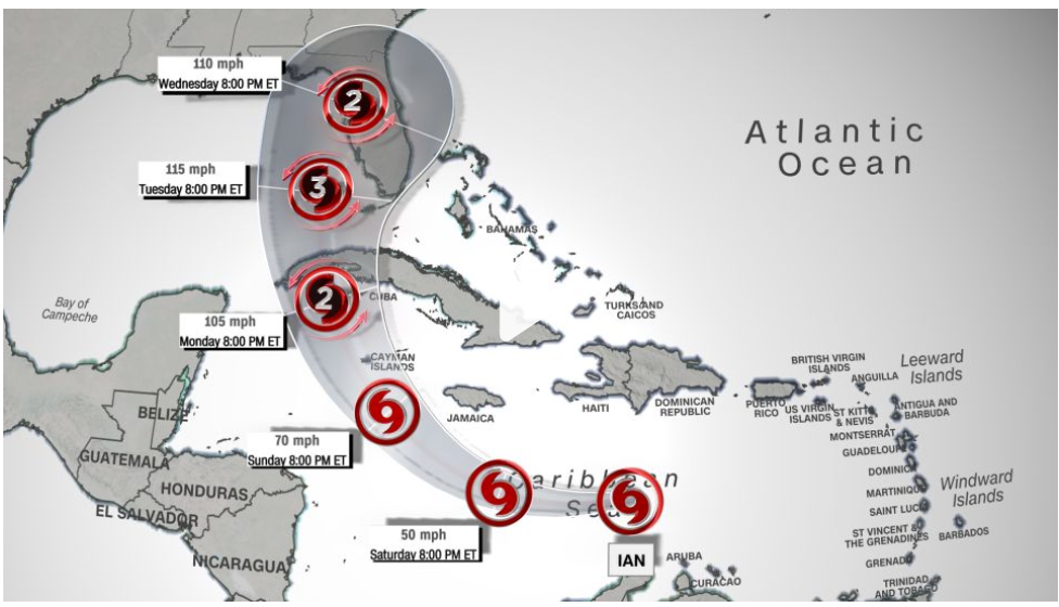
Tropical Storm Ian was located about 270 miles south-southeast of Kingston, Jamaica, as of 2 p.m. Saturday and moving west at 16 mph, according to the National Hurricane Center. “Significant strengthening is forecast during the next few days,” the center said.
The forecast shows Ian “as a major hurricane over the eastern Gulf when it is approaching the west coast of Florida,” after briefly passing over Cuba at or near major hurricane strength, the center said Friday. Much of the Gulf Coast of Florida, including the eastern Panhandle, could be at risk.
Forecast models on Saturday afternoon vary on where Ian may make landfall on Florida’s coast. The European model shows landfall near Tampa on Thursday morning, while the American model shows landfall near Pensacola Friday morning.
The official hurricane center track splits the difference between the models, showing landfall north of Tampa on Thursday morning.
Florida Gov. Ron DeSantis on Saturday expanded an emergency order from 24 counties to include the whole state, citing “foregoing conditions, which are projected to constitute a major disaster.”
“The Florida Division of Emergency Management, working together with the National Hurricane Center to evaluate weather predictions, has determined there is a continuing risk of dangerous storm surge, heavy rainfall, flash flooding, strong winds, hazardous seas, and isolated tornadic activity for Florida’s Peninsula and portions of the Florida Big Bend, North Florida, and Northeast Florida,” the order states.
Tropical storm-force winds could begin to affect southwest Florida early Tuesday, with landfall possible on Wednesday or Thursday.
After strengthening overnight, the storm – earlier known as Tropical Depression Nine – has maximum sustained winds of 45 mph (75 km/h) and is forecast to reach hurricane status within the next two days as it approaches the Cayman Islands by early Monday. Further strengthening is anticipated as the system approaches and crosses western Cuba by Monday evening.
“Ian is likely to be near major hurricane intensity when it approaches western Cuba,” the hurricane center said. “Since Ian is not expected to remain over Cuba long, little weakening is expected due to that land interaction.”
If it strengthens to a Category 3 or higher before reaching Florida, it would be the first major hurricane to make landfall there since Hurricane Michael in 2018, which was a monster Category 5 storm when it collided with the Florida panhandle. Michael also underwent rapid intensification before it made landfall, a phenomenon which has been made more likely as ocean temperatures warm due to the climate crisis.
Leave a Reply
You must be logged in to post a comment.